

Topographical surveys provide a measured record of the physical features, levels and layout of a site. They are commonly commissioned before planning, design, construction, drainage, landscaping and infrastructure work begins.
The completed survey gives architects, engineers, developers and other project professionals reliable information on which to base their work. Depending on the agreed brief, it may show ground levels, contours, buildings, roads, drainage features, trees, structures, visible boundaries and surface evidence of utilities.
This topographical survey guide explains what a survey records, when one may be required, how the site work is carried out, which outputs can be supplied and what information is needed to prepare an accurate quotation.
1. Topographical Survey Guide: What Is a Topographical Survey?
A topographical survey is a measured survey of the natural and constructed features within a defined area of land. It records the position and height of visible features so the existing site can be represented in two-dimensional drawings, three-dimensional data or other agreed digital formats.
The word “topographical” refers to the shape, levels and physical characteristics of the land. A survey therefore records both the terrain and the relevant features located on it.
Depending on the project requirements, it may include:
- Ground levels, spot heights and contours
- Buildings, extensions and other structures
- Roads, kerbs, paths and hard surfaces
- Walls, fences, hedges and visible boundary features
- Drainage covers, channels, ditches and visible outfalls
- Trees, vegetation and changes in ground cover
- Street furniture and highway features
- Visible utility equipment and overhead cables
The required features and level of detail should be agreed before the site survey because no single specification is suitable for every project.
2. When Is a Topographical Survey Needed?
Topographical surveys are normally commissioned during the early stages of planning, design or construction. They provide the measured base information needed to understand the existing site and coordinate proposed work with current conditions.
Planning applications
Architects and planning consultants may need accurate site information to prepare existing and proposed layouts, planning drawings and supporting documents. The survey can show the relationship between buildings, access routes, ground levels, neighbouring features and the proposed development area.
Architectural and engineering design
Designers require reliable information before developing foundations, access arrangements, drainage systems, retaining structures and external works. Incomplete base information can cause design conflicts, additional site visits and avoidable revisions later in the project.
Drainage and flood-risk work
Levels, slopes, channels, watercourses and drainage features can be recorded to support drainage design and flood-risk assessment. A topographical survey does not determine flood risk, but it can provide terrain and level data for the relevant specialist.
Roads and infrastructure
Survey data can support the design or alteration of roads, paths, car parks, junctions, utilities and other infrastructure. A highway brief may also include kerbs, road markings, signs, lighting columns, drainage features, barriers and other visible assets.
Landscaping and external works
Landscape architects may use measured site information to design levels, planting areas, paths, walls, terraces and drainage. Accurate ground data is particularly important where proposed work must connect with existing thresholds, roads or adjoining land.
Earthworks and volume calculations
Measured terrain data can support cut-and-fill calculations, stockpile volumes and comparisons between ground surfaces. Repeat surveys may also be undertaken to record how a site changes during a project.
3. What Does a Topographical Survey Show?
The completed drawing or dataset shows the features included within the agreed survey brief. This topographical survey guide describes the most common content, but the final scope must be matched to the intended use of the information.
Ground levels and contours
Spot levels record the height of selected points across the site. Contours connect points of equal elevation and provide a visual representation of the shape and gradient of the land. The contour interval should suit the terrain, survey accuracy, drawing scale and project requirements.
Buildings and structures
The survey may show the plan position of buildings, extensions, outbuildings, walls, retaining structures and other visible construction. Where required, it can also record threshold levels, finished-floor levels, roof ridges, eaves, canopies and neighbouring buildings.
Projects requiring internal layouts, floor plans, elevations or sections will normally need a separate measured building survey.
Boundaries, walls and fences
Visible walls, fences, hedges and other physical boundary features can be surveyed. However, the drawing records what is visible on site; it does not automatically establish the legal ownership boundary or determine who owns a wall, fence or strip of land.
Roads, paths and hard surfaces
Road edges, kerb lines, footways, tracks, car parks, access points, dropped kerbs, surface changes and road markings may be included where relevant to the project.
Drainage features
Visible drainage information can include manhole covers, gullies, channels, headwalls, ditches, outfalls and accessible culverts. Opening covers, measuring pipe sizes, recording invert levels or tracing underground drainage requires additional work and must be included clearly within the brief.
Trees and vegetation
Trees may be recorded by trunk position, canopy spread and an agreed identifier or description. Hedges, woodland edges and significant vegetation can also be shown. A separate arboricultural survey may still be required to assess species, condition, root-protection areas or planning constraints.
Visible utilities and street furniture
The survey may record inspection covers, valve covers, hydrants, cabinets, poles, lighting columns, pylons, overhead cables, signs and bollards. It does not locate buried services unless a separate utility survey forms part of the commissioned work.
4. How Are Topographical Surveys Carried Out?
The survey method is selected according to the site, terrain, vegetation, access, required accuracy and intended outputs. The following process provides the practical framework used throughout this topographical survey guide.
Reviewing the brief
Before site attendance, the surveyor reviews the required survey boundary, site features, coordinate system, level datum, file formats, access arrangements and delivery programme. A marked-up plan is especially useful because a postal address alone may not define the full extent of the work.
Establishing survey control
Survey control consists of coordinated reference points established around the site. These allow measurements taken from different positions to be linked together consistently and provide a framework against which the survey can be checked.
Total station surveying
A total station measures horizontal angles, vertical angles and distances to surveyed points. It is commonly used to record buildings, walls, kerbs, drainage covers, visible boundaries and other detailed site features.
GNSS surveying
Survey-grade Global Navigation Satellite System equipment may be used to establish control and measure suitable features in open areas. It can also help relate the work to an agreed national or project coordinate system. The Ordnance Survey guidance on coordinate transformations explains how positions can be connected to British National Grid coordinates and national height datums. Satellite observations may be restricted near buildings, dense tree cover or other locations with an obstructed view of the sky.
3D laser scanning
3D laser scanning can capture dense three-dimensional point-cloud data across complex sites and structures. Additional observations may still be needed for obscured features, survey control and the identification of particular objects.
Aerial drone surveying
Aerial drone surveying can support mapping across larger, open or difficult-to-access areas. Depending on the equipment and specification, aerial imagery or LiDAR data may be processed into point clouds, terrain models, orthomosaic imagery and contours. Ground observations are often required for survey control, checks and features hidden from the air.
Processing and quality checks
After the site work, the observations are processed and reviewed before the final drawing or model is produced. Checks may include survey-control closure, comparison with independent points, review of levels and contours, identification of missing or duplicated features and verification of coordinate and datum information.
5. What Outputs Can Be Supplied?
The required deliverables should be agreed before the survey because design teams use different software, drawing standards and data formats. This part of the topographical survey guide covers the principal options.
2D CAD drawings
A two-dimensional topographical survey drawing normally presents site features, levels, contours, annotations and symbols in plan view. Common formats include DWG and DXF.
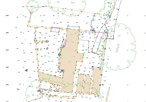
Example CAD drawing produced from a topographical survey.
3D CAD data
Three-dimensional linework, breaklines and surveyed points can be supplied where designers need level information for modelling, engineering or terrain analysis.
PDF survey drawings
A PDF provides an accessible visual copy for review, printing and distribution. Where further technical design is required, the editable CAD file normally remains the principal dataset.
Point-cloud data
Where laser scanning, photogrammetry or aerial LiDAR is used, registered point-cloud data may be supplied in an agreed format.
Terrain and surface models
A digital terrain model represents the ground surface. A digital surface model may also include buildings, trees and other objects above ground. These datasets can support drainage, engineering, visualisation and earthworks design.
6. How Accurate Is a Topographical Survey?
There is no single accuracy figure that applies to every topographical survey. The appropriate accuracy depends on the project purpose, site conditions, drawing scale, survey method, equipment and required deliverables.
Factors influencing the finished survey include:
- The quality and arrangement of survey control
- The equipment and observation method used
- Instrument setup and measurement distances
- GNSS reception conditions
- Vegetation, buildings and other obstructions
- Access restrictions and the density of measured points
- The terrain and required level of detail
- The processing and checking procedures
The intended use should be explained at quotation stage so the surveyor can propose an appropriate method, accuracy and level of detail.
7. What Are the Limitations?
A topographical survey provides a measured record of visible and accessible site features. Unless expressly included within the brief, it does not normally provide:
- Legal boundary determination
- Underground utility detection
- Ground-condition or geotechnical information
- Flood-risk conclusions
- Structural assessment
- Tree-condition assessment
- Internal building measurements
- Drainage tracing or CCTV inspection
These requirements may need separate specialist surveys or investigations.
8. How Much Does a Topographical Survey Cost?
The cost depends on the scope and complexity of the work rather than site area alone. Two similarly sized sites can require very different amounts of fieldwork and processing.
Factors affecting the quotation may include:
- The survey area and density of site features
- The terrain, vegetation and visibility
- The required accuracy and level of detail
- Access, parking and working restrictions
- Traffic-management or site-safety requirements
- The coordinate system and level datum
- The amount of survey control required
- The drawing, model and data formats requested
- The project programme and site location
A clear brief allows the survey company to prepare a more accurate quotation and reduces the risk of omitted items or additional work later.
9. What Information Is Needed for a Quotation?
When requesting a quotation, provide as much of the following information as possible:
- The site address or location
- A plan clearly marking the required survey boundary
- The approximate site area
- The intended use of the survey
- The features and level of detail required
- The coordinate system and level datum, if specified
- The required CAD, PDF, model or data formats
- Any client or project survey specification
- Known access restrictions, hazards or working-hour limits
- The required completion date
If the requirements are uncertain, they should be discussed with the design team and surveyor before the work begins.
10. Frequently Asked Questions
These are some of the questions most frequently addressed by this topographical survey guide.
Is a topographical survey the same as a boundary survey?
No. A topographical survey can record visible walls, fences and hedges, but it does not automatically determine the legal ownership boundary.
Does a topographical survey show underground services?
It can show visible covers and utility equipment. Locating and tracing buried services normally requires a separate utility survey using appropriate detection methods and available records.
Can neighbouring buildings be shown?
Yes, where the relevant parts are visible and included within the agreed brief. Information may include building positions, roof ridges, eaves and other visible levels.
Can a drone produce a topographical survey?
Drone data can support topographical mapping, particularly across larger or open sites. Ground measurements may still be required for obscured features, small details, survey control and independent checks.
How long does a topographical survey take?
The programme depends on the size and complexity of the site, access, weather, required detail and the amount of processing and drawing work involved.
Who uses topographical survey drawings?
They are commonly used by architects, engineers, developers, planning consultants, landscape architects, drainage consultants, construction companies and property professionals.
11. Topographical Surveys from Pinpoint Mapping
Pinpoint Mapping provides topographical survey services for planning, design, engineering and development projects across Bristol, Bath, the South West and other parts of the UK.
Depending on the agreed brief, deliverables may include two-dimensional CAD drawings, three-dimensional survey data, spot levels, contours, building and boundary information, road and drainage features, tree and vegetation information, registered point clouds, terrain models and PDF survey drawings.
12. Request a Topographical Survey Quotation
To request a quotation, send us the site location, a clearly marked survey boundary, the required outputs and any available project specification.
Use our Request a Survey Quotation form or contact Pinpoint Mapping directly. We will review the information and prepare a quotation based on the required survey scope.
This topographical survey guide provides general information. The exact survey method, coverage, accuracy and deliverables will be confirmed for the individual project.