
Accurate Site Information for Confident Project Decisions
Pinpoint Mapping provides accurate topographical surveys in Bristol, Bath and across the South West, capturing measured information about land, buildings, levels, boundaries, visible site features and site constraints.
Our topographical surveys support architects, planning consultants, property developers, engineers, contractors and construction professionals who need reliable site data for planning applications, architectural design, site development, engineering design and construction projects.
Each survey creates a coordinated record of the visible site features and levels required by the project. Well-scoped surveys also help reduce uncertainty before design work starts, because the project team can see the existing ground conditions, access routes, surface changes, visible constraints and surrounding features in one clear drawing package. This is useful when layouts, drainage proposals, access arrangements, levels, ownership information and construction details need to be checked against real site conditions before drawings are developed further. The survey extent, level of detail, coordinate system and final deliverables are agreed before work begins, so the finished information is suitable for the intended planning, design or construction use. It also gives your design team a clearer shared reference for early conversations, helping reduce wasted time, duplicated checks and avoidable assumptions when drawings, layouts, levels and access arrangements are being reviewed.
For a more detailed explanation of survey methods, outputs, limitations and cost factors, read our topographical survey guide.
Where a project also involves an existing building or complex structure, we can combine the site survey with a measured building survey, 3D laser scanning or registered 3D point cloud data. For suitable sites, aerial drone surveys can also support wider visual coverage alongside ground-based survey methods.
What a Topographical Survey Records
The precise survey content is agreed for each project. The survey can record the visible physical features, levels and site constraints needed by the design team.
Levels and Terrain
- Spot levels and level changes
- Slopes, banks and changes of gradient
- Contours where required by the brief
- Ground surfaces and surface transitions
- Three-dimensional strings and breaklines where specified
Buildings, Boundaries and Surfaces
- Building footprints and visible structures
- Walls, fences, hedges and visible boundaries
- Roads, kerbs, paths and access routes
- Hardstanding, paved areas and surface edges
- Adjacent features where required by the project
Drainage, Trees and Site Features
- Gullies, channels and visible drainage features
- Inspection covers and visible service covers
- Trees, significant vegetation and landscaping
- Street furniture, signs and other visible features
- Project-specific detail identified in the survey brief
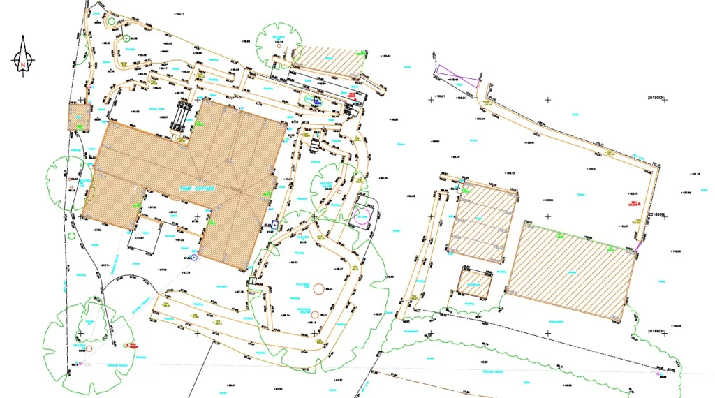
Example Topographical Survey Drawing
This example shows how measured site information from a topographical survey can be prepared as an accurate CAD drawing for planning, design and construction projects. Surveyed features are presented in a clear, coordinated format for use by architects, engineers, developers and other project professionals.
Depending on the agreed survey brief, topographical survey deliverables can include:
- 2D or 3D survey drawings in DWG format
- PDF plans for review, issue and planning use
- Site levels, boundaries, buildings, roads and kerbs
- Drainage features, inspection covers and visible service covers
- Trees, vegetation, walls, fences and other visible site features
The measured survey data can be developed into professional CAD survey drawings for use as a base for architectural, engineering and development work. Read our guide to CAD survey drawings and how they are produced
to discover more information about drawing formats, survey methods and typical applications.
Where required, survey data can also be related to the Ordnance Survey National Grid and heights related to Ordnance Datum Newlyn (ODN), or supplied using an appropriate local site grid.
Need Accurate Site Survey Data for Your Project?
Send us the site location, required survey area and intended use, and we’ll advise on the appropriate survey scope, deliverables, topographical survey cost factors and next steps.
Request a Survey QuotationWhen Do You Need a Topographical Survey?
A measured site survey helps the project team understand the existing site before proposals are developed, submitted for approval or taken forward into detailed design and construction.
Planning and Feasibility
Measured site levels, boundaries, buildings and visible constraints provide a reliable base for feasibility studies, planning applications and early design proposals.
Detailed Design
Architects and engineers use coordinated site information to develop layouts, access arrangements, drainage designs, levels and construction information.
Development and Construction
Developers, contractors and project managers use survey data to understand existing conditions, coordinate proposed work and prepare construction or as-built records.
Survey Methods Selected for the Site and Project
The survey method is selected to suit the site conditions, required accuracy, level of detail and intended outputs. For many topographical surveys, one method or a combination of survey technologies may be used.
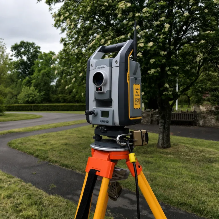
Trimble total station used by Pinpoint Mapping to capture precise site detail and levels during a topographical survey.
Total Station Surveying
Survey-grade total stations are used to measure coordinated site detail, levels and control points. They are well suited to recording defined features, breaklines, boundaries and changes in level.
GNSS Survey Control
GNSS equipment can establish survey control and relate the work to the Ordnance Survey National Grid and Datum where site conditions and the project brief require it.
3D Laser Scanning
Our survey-grade Trimble X9 3D laser scanner can capture dense measured information across complex structures, surfaces and site features. Registered 3D point cloud data can also be supplied where required.
For suitable sites, aerial imagery or drone surveying can support wider coverage or provide current visual information alongside ground-based measurements, subject to the required accuracy, site conditions and flight restrictions.
Survey Scope Agreed in Advance
Before site attendance, we confirm the survey boundary, required site coverage, visible features and levels, coordinate system, datum, output formats, access arrangements and delivery programme.
A marked-up plan showing the required survey extent is usually the clearest way to define the work.
Why Choose Pinpoint Mapping for Topographical Surveys?
Pinpoint Mapping is an owner-led measured survey practice based near Bristol. If you need a topographical survey company, we provide clear scope, direct communication and practical CAD deliverables for planning, design and development projects.
Contact us to discuss your site.
Clear Project Scope
The survey extent, required features, coordinate system, level of detail and final deliverables are agreed before site work begins, helping avoid assumptions and gaps in the survey brief.
Practical CAD Deliverables
Survey drawings and digital data are prepared for practical use in planning, architectural design, engineering, construction and project coordination.
Appropriate Survey Technology
Total station, GNSS and 3D laser scanning methods are selected to suit the site conditions, required accuracy and intended survey outputs.
Regional Service and Direct Contact
Based near Bristol, we provide topographical surveys across Bristol, Bath, Gloucestershire, Somerset, Wiltshire, South Wales and the wider South West.
A Clear Topographical Survey Process
Our topographical surveys start by establishing the project requirements, capturing the agreed site information and preparing the completed drawings or digital data for practical use by your project team.
STEP 1
Review the Requirements
We review the site location, proposed survey area, required detail, available information, intended outputs and project timescale.
STEP 2
Agree the Scope
The survey limits, recorded features, control requirements, access arrangements, quotation and expected programme are confirmed.
STEP 3
Survey and Process
The site is surveyed using suitable equipment. The captured information is then checked, processed and prepared for drawing production.
STEP 4
Check and Deliver
Completed drawings and data are checked and issued in the agreed formats using the confirmed coordinate system and delivery arrangements.
Topographical Survey Bristol and Topographical Survey Bath Coverage
Pinpoint Mapping provides topographical surveys across Bristol, Bath and the wider South West for planning, design, development and construction projects. Whether you need a topographical survey Bristol project teams can rely on, or a topographical survey Bath project for planning or design, we can advise on the appropriate survey scope and deliverables.
Our regular coverage includes Gloucestershire, Somerset, Wiltshire, South Wales and surrounding areas. Projects farther afield can also be considered where the survey scope and programme justify the required travel.
See the locations we cover, request a survey quotation or send us the project location for confirmation.
Typical Coverage
- Bristol
- Bath
- Gloucestershire
- Somerset
- Wiltshire
- South Wales
- Wider South West
Topographical Survey FAQs
Answers to common questions about topographical surveys, survey content, CAD deliverables and project requirements.
Do you provide a topographic survey Bristol service?
Yes, if you are searching for a topographic survey Bristol service, the usual requirement is a measured topographical survey drawing for planning, design or construction use. The terms are commonly used to describe the same type of measured site survey. In the UK, both “topographic survey” and “topographical survey” are used for surveys that record site levels, visible features and existing conditions.
Do you provide topographical survey Bath services?
Yes. We provide topographical survey Bath services for planning, design, development and construction projects, as well as wider coverage across Bristol and the South West.
What does a topographical survey include?
A topographical survey can include site levels, spot heights, buildings, walls, fences, boundaries, roads, kerbs, paths, drainage covers, trees, vegetation, hardstanding and other visible site features. The final content depends on the site and the agreed project requirements.
How is topographical survey cost calculated?
Topographical survey cost depends on the size and complexity of the site, the required level of detail, access conditions, survey control requirements, deliverable formats and project timescale. A marked-up plan showing the required survey extent is usually the clearest way for us to prepare an accurate quotation.
Do you provide DWG and PDF files?
Yes. Topographical survey drawings can be supplied in DWG and PDF formats. The required CAD version, layer convention, scale and drawing presentation should be confirmed at quotation stage.
Can you provide 3D topographical survey data?
Yes. Three-dimensional survey strings, breaklines, levels and other agreed 3D information can be supplied where required. This should be requested before the quotation is prepared because the required processing can affect the project scope and cost.
Can the survey be related to the Ordnance Survey National Grid?
Yes, where this is required and suitable for the project. A survey can be related to the Ordnance Survey National Grid and Datum, or completed on an agreed local site grid. The required coordinate system should be confirmed before site work begins.
Does a topographical survey include underground services?
A standard topographical survey records visible surface features, including visible inspection covers and service covers where required. It does not confirm the position or depth of underground utilities. A separate utility survey may be required where buried services need to be identified.
What survey equipment do you use?
We use professional survey equipment including total stations, GNSS and 3D laser scanning equipment where appropriate for the site, required accuracy and intended project outputs.
How accurate is a topographical survey?
The required accuracy depends on the project, site conditions, survey control, feature type and intended use. We agree the survey scope and control requirements before work begins rather than applying one general accuracy figure to every project.
How long does a topographical survey take?
The time required depends on the size and complexity of the site, the level of detail, access arrangements and final outputs. Smaller surveys may be completed during one site visit, while larger or more detailed projects require additional fieldwork and processing.
Do you cover Bristol, Bath and the South West?
Yes. Pinpoint Mapping provides topographical surveys across Bristol, Bath, Gloucestershire, Somerset, Wiltshire, South Wales and the wider South West.
Discuss Your Topographical Survey Requirements
Send us the site address, required survey area, intended use and preferred survey deliverables.
We will review the information and advise on the appropriate survey scope, control, outputs and quotation for your project. Clear topographical surveys begin with a clear brief.