
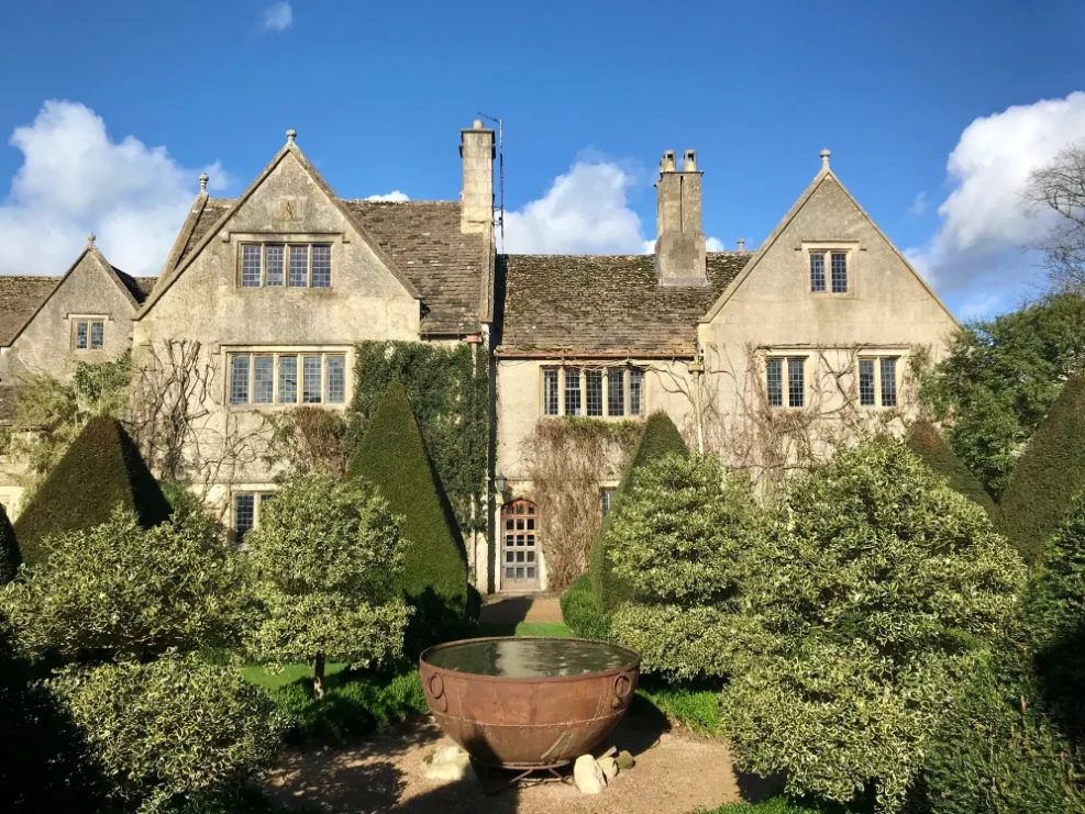
Historic buildings often contain irregular walls, uneven floors, complex roof forms, decorative features and evidence of several phases of alteration. Recording this accurately can be difficult using limited manual measurements alone.
3D laser scanning for historic buildings provides a detailed measured record of the visible structure and architectural features. The resulting point cloud can then support conservation, refurbishment, planning, design and archival work.
This guide explains how historic buildings are surveyed using terrestrial laser scanners, what information can be captured, which outputs can be produced and where the limitations lie.
What Is 3D Laser Scanning for Historic Buildings?
3D laser scanning is a surveying method used to record the dimensions and visible geometry of an existing building.
A terrestrial laser scanner measures the distance and angle to surrounding surfaces from a series of positions. These measurements create a dense three-dimensional point cloud representing the parts of the building visible from each scanner location.
For a historic property, the point cloud may record:
- External elevations
- Internal walls and partitions
- Floor and ceiling levels
- Doors and windows
- Staircases
- Columns, arches and vaults
- Roof geometry
- Timber framing
- Decorative architectural features
- Visible changes in construction
- Irregular or distorted building geometry
The point cloud forms a measured source dataset from which drawings, models and other survey outputs can be produced.
Why Are Historic Buildings Difficult to Survey?
Historic buildings are rarely simple or uniform. They may have been extended, repaired or altered several times, often using different materials and construction methods.
Common surveying challenges include:
- Walls that are not straight, square or vertical
- Uneven floor and ceiling levels
- Complex roof structures
- Restricted roof spaces and cellars
- Thick walls and deep window reveals
- Decorative plasterwork and timber detailing
- Narrow staircases and corridors
- Multiple phases of construction
- Limited access to fragile or sensitive areas
- Vegetation or nearby structures obscuring elevations
3D laser scanning for historic buildings is particularly useful where irregular geometry, sensitive interiors and multiple phases of construction need to be recorded accurately. These features can make historic buildings time-consuming to record using isolated measurements. Laser scanning allows much more of the visible geometry to be captured during the site visit.
How Does the Survey Process Work?
1. Confirming the Survey Brief
The first stage is to establish why the building is being surveyed and which information the project team requires.
The brief may confirm:
- The areas of the building to include
- Whether internal and external surveys are required
- The required floor plans, elevations and sections
- Whether roof plans or roof-space information are needed
- The required drawing scale
- The required level of detail
- The coordinate system and level datum
- Whether point-cloud data is required
- Whether a three-dimensional model is required
- Any access or conservation restrictions
A clear brief is essential because scanning a building does not automatically include the production of every possible drawing or model.
2. Reviewing Access and Site Conditions
Before scanning begins, the surveyor reviews access throughout the property.
This may include:
- Occupied rooms
- Locked or restricted areas
- Roof spaces
- Basements and cellars
- External courtyards
- Fragile floors or staircases
- Areas requiring specialist access equipment
- Features that must not be touched or disturbed
Historic buildings may require additional care when positioning equipment, moving through sensitive interiors or working around original finishes and fittings.
3. Establishing Survey Control
Survey control provides a coordinated framework for the scanning work.
Control points may be established using a total station, GNSS equipment or another appropriate survey method. These points can help connect internal and external survey data, relate different floors to one another and check the completed registration.
The survey can be related to a local site grid, an existing project coordinate system or national coordinates where required by the brief.
4. Planning Scanner Positions
A laser scanner records visible surfaces using line of sight. It cannot measure through walls, furniture, vegetation or other obstructions.
The surveyor therefore plans a series of overlapping scanner positions throughout and around the building.
Scanner positions may be required:
- Inside individual rooms
- Along corridors
- At staircases and landings
- Within roof spaces
- Inside cellars and basements
- Around external elevations
- Inside courtyards
- Near architectural features requiring additional detail
Complex spaces may require more scanner positions to reduce hidden areas and maintain sufficient overlap between scans.
5. Capturing the Building
At each position, the scanner measures the surrounding visible surfaces and creates a three-dimensional set of points.
Modern scanners may also capture photographic imagery so that colour can be applied to the point cloud. This can make the data easier to interpret and navigate.
The scanning settings may vary according to:
- The size of the space
- The distance to the surfaces
- The complexity of the geometry
- The required level of detail
- The intended survey output
- The available site time
The surveyor continues through the building until the required areas have been captured.
6. Registering and Checking the Scans
Each scanner position initially creates a separate dataset. These scans must then be joined together through a process known as registration.
Registration may use overlapping geometry, targets, survey control or a combination of methods.
The completed point cloud should be reviewed for:
- Missing coverage
- Registration issues
- Obscured features
- Movement within the scans
- Consistency with survey control
- Suitability for the required drawings or model
Independent measurements and survey-control checks may also be used where appropriate.
What Is a Point Cloud?
A point cloud is a collection of measured points with three-dimensional coordinates.
Viewed together, these points form a detailed representation of the visible building surfaces. The point cloud may also contain colour or intensity information depending on the equipment and survey settings.
A point cloud is not a finished floor plan, elevation or BIM model. It is the measured dataset from which those outputs can be prepared.
Further information is available on our 3D laser scanning service page.
What Survey Drawings Can Be Produced?
Floor Plans
Horizontal sections through the point cloud can be used to prepare measured floor plans.
These may show:
- External and internal walls
- Doors and windows
- Stairs
- Columns and structural features
- Room layouts
- Floor-level information
- Fixed architectural features
- Other details required by the project brief
External Elevations
External elevations can be produced from orthographic views of the registered point cloud.
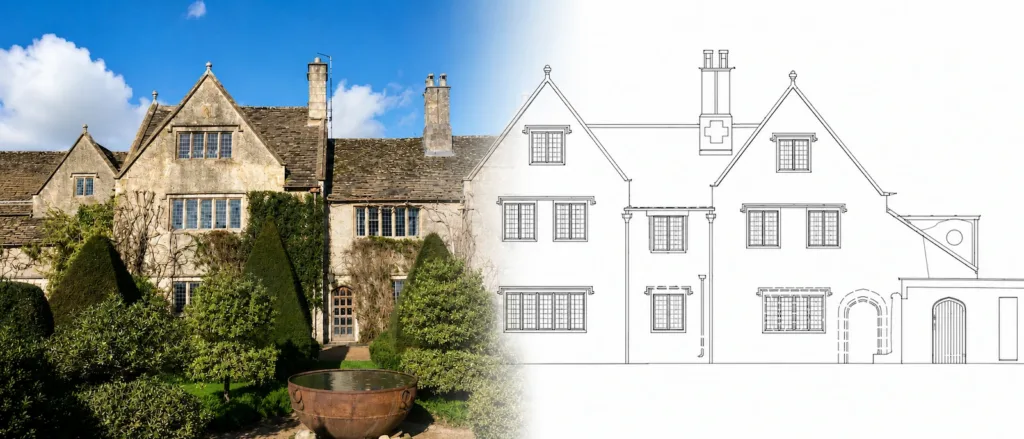
Historic building survey data used to produce a measured façade elevation drawing.
Depending on the brief, they may show:
- Wall outlines
- Doors and windows
- Roof lines
- Ridges, hips and valleys
- Parapets and chimneys
- Rainwater goods
- Visible construction materials
- Decorative architectural features
- Changes in level
Internal Elevations
Internal elevations may be required where the project involves decorative interiors, fitted features, historic joinery, fireplaces, panelling or other significant internal details.
Building Sections
Vertical sections through the point cloud can show the relationship between floors, ceilings, staircases, roof structures and changes in level.
Sections are often particularly useful in historic buildings where floor levels vary or the building contains irregular structural arrangements.
Roof Plans
Laser scanning can help record ridges, hips, valleys, parapets, rooflights and changes in roof level.
Some roof areas may remain hidden from ground-based scanner positions and may require elevated access, aerial survey data or additional measurements.
Further details about drawing production are available on our measured building surveys page.
How Can Laser Scanning Support Conservation and Restoration?
Conservation and restoration work often requires a reliable record of the building before design or construction begins.
Measured survey data can help architects, conservation specialists and engineers understand:
- The existing building layout
- The relationship between different floors and structures
- Irregular or distorted geometry
- The position of important architectural features
- The relationship between historic and later additions
- The areas affected by proposed alterations
- The dimensions needed for repair or replacement work
The point cloud also creates a dated spatial record of the visible building at the time of the survey.
It is important to distinguish this from a building-condition survey. Laser scanning records visible geometry and appearance, but it does not automatically diagnose structural defects, decay, damp, material failure or the causes of cracks.
Those matters may require assessment by a conservation architect, structural engineer, building surveyor or other suitably qualified specialist.
Can Laser Scanning Record Historic Features?
Laser scanning can record the visible shape and position of architectural features, provided they are within range and visible from the scanner positions.
These may include:
- Stonework
- Arches and vaults
- Timber framing
- Decorative mouldings
- Fireplaces
- Staircases
- Columns and capitals
- Window tracery
- Panelling
- Roof structures
The appropriate scanning density and output should be agreed before the survey. A general measured building survey may not capture the same level of fine detail as a specialist survey focused on an individual feature.
Can Historic Building Data Be Archived?
Registered point clouds and survey drawings can form part of a digital archive of the building.
Depending on the agreed scope, archived information may include:
- Registered point-cloud files
- CAD drawings
- PDF survey drawings
- Photographic records
- Three-dimensional models
- Survey-control information
Long-term archiving should consider file formats, storage arrangements, backups and future software compatibility.
The files supplied and any retention arrangements should be agreed as part of the project brief rather than assumed to be included automatically.
Can a BIM Model Be Produced?
A BIM model can be created using the registered point cloud as measured reference data.
However, the point cloud does not automatically become a BIM model. Model production requires additional interpretation and office work.
The modelling brief should confirm:
- The areas to be modelled
- The required software format
- The required level of detail
- The required modelling tolerance
- Which architectural or structural elements to include
- How irregular and historic features should be represented
- Whether later phases or materials need to be identified
Historic buildings can be particularly challenging to model because their geometry may not fit standardised BIM components.
What Are the Benefits of 3D Laser Scanning for Historic Buildings?
Detailed Measured Information
The scanner records a dense set of measurements across visible surfaces, providing more comprehensive spatial information than a limited number of isolated dimensions.
Recording Irregular Geometry
Curved walls, uneven floors, distorted structures and complex roof forms can be represented within the point cloud.
Reduced Physical Contact
Many measurements can be collected remotely from the scanner position, reducing the need to place measuring equipment directly against sensitive surfaces.
Support for Multiple Outputs
The registered dataset may support floor plans, elevations, sections, point-cloud files and three-dimensional models.
Digital Record of Existing Conditions
The point cloud creates a detailed record of the visible building at the time of the survey.
Reduced Need for Return Visits
Additional dimensions and views may be obtained from the point cloud later, provided the relevant surfaces were captured clearly during the original survey.
What Are the Limitations?
Line of Sight
The scanner cannot measure through solid objects. Features hidden behind furniture, panelling, vegetation, ceilings or other obstructions will not be recorded from that position.
Restricted Access
Fragile floors, locked rooms, unsafe roof spaces or conservation restrictions may limit where the scanner can be positioned.
Reflective and Transparent Surfaces
Glass, mirrors, highly reflective finishes and some dark or wet materials can produce incomplete or noisy data.
Movement
People, vehicles, vegetation and moving objects may create unwanted or duplicated points.
Interpretation Is Still Required
The scanner records measured points but does not automatically identify construction materials, building phases, structural defects or heritage significance.
Not Every Detail Is Automatically Included
The amount of detail captured and drawn depends on the survey brief, scanning settings, access and intended output.
Large File Sizes
Point-cloud datasets can be large and may require suitable software, storage and computer hardware.
Planning and Listed Building Considerations
Development affecting a listed building or historic environment may require specialist planning and conservation advice.
The measured survey provides information about the existing building, but it does not determine whether proposed work is permitted or whether listed building consent is required.
Government guidance on conserving and enhancing the historic environment explains the planning framework relating to heritage assets.
Project teams should obtain advice from the relevant local planning authority, conservation officer and suitably qualified professional before undertaking alterations to a protected building.
What Information Is Needed for a Quotation?
To prepare an accurate quotation, it is helpful to provide:
- The property address
- Available plans or photographs
- The approximate size and number of floors
- The areas to be surveyed
- Whether internal and external surveys are required
- Any roof spaces, cellars or restricted areas to include
- The required floor plans, elevations and sections
- The required point-cloud or model formats
- The required coordinate system and datum
- Known access or conservation restrictions
- The required completion date
A clear scope helps ensure the survey captures the required information and that the quotation includes the correct outputs.
Frequently Asked Questions
Does laser scanning damage historic surfaces?
Terrestrial laser scanning is a non-contact measuring method. The scanner records visible surfaces remotely, although targets, survey-control equipment or access arrangements may still be required around the property.
Can 3D laser scanning detect structural defects?
It can record visible geometry and surface information, but it does not automatically diagnose structural defects or their causes. Specialist inspection may still be required.
Can it scan through walls or ceilings?
No. Laser scanning records visible surfaces and cannot see through solid construction.
Can the point cloud be used to produce drawings later?
Potentially, provided the required areas and level of detail were captured during the original survey. Further site work may be needed where features were hidden, inaccessible or excluded.
Can laser scanning be used in an occupied historic building?
Yes, although furniture, visitors, restricted rooms and movement may affect the scanning programme and the completeness of the data.
Is laser scanning suitable for small historic properties?
It can be, particularly where the building has irregular geometry or several drawings are required. For a very small and simple scope, another measured survey method may be more efficient.
Historic Building Surveys from Pinpoint Mapping
Pinpoint Mapping provides 3D laser scanning and measured building surveys for historic, listed and period properties across Bristol, Bath, the South West and other parts of the UK.
Depending on the project brief, outputs may include:
- Registered point-cloud data
- Measured floor plans
- External elevations
- Internal elevations
- Building sections
- Roof plans
- Three-dimensional CAD information
- BIM models
- PDF survey drawings
Each survey is planned around the building, access conditions and required deliverables.
Request a Historic Building Survey Quotation
Pinpoint Mapping provides 3D laser scanning for historic buildings across Bristol, Bath, the South West and other parts of the UK.
To request a quotation, send us the property location, the areas to be surveyed, the required outputs and any available plans, photographs or project specification.
Contact Pinpoint Mapping by telephone or email, or use the Request a Quote form on our website. We will review the information and provide a quotation based on the required scope.