
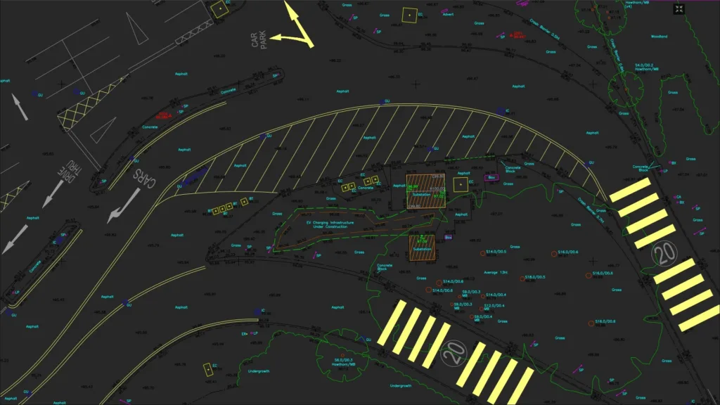
What Is a CAD Survey?
A CAD survey provides accurate measured information about a building, site or area of land in a digital drawing format that can be used by architects, engineers, developers, planning consultants and construction professionals.
Rather than relying on historic drawings, estate-agent plans or approximate measurements, a professional CAD survey is produced from measurements collected on site using appropriate survey equipment. The resulting information can then be supplied as accurate CAD survey drawings for use throughout the design, planning and construction process.
At Pinpoint Mapping, CAD survey drawings can be produced from topographical surveys, measured building surveys and 3D laser scanning surveys, depending on the property, site and information required.
We provide measured survey and CAD drawing services across Bristol, Bath, Gloucestershire, Somerset, Wiltshire and South Wales, with projects undertaken throughout the UK by arrangement.
How Is a CAD Survey Produced?
The term CAD survey is commonly used to describe a measured survey where the resulting site or building information is supplied as a Computer-Aided Design drawing.
CAD itself is not the method used to measure the site. The measurements are collected using professional survey equipment and then processed to create accurate digital drawings.
Depending on the type and complexity of the project, survey information may be captured using:
- Total station survey equipment
- GNSS and GPS survey equipment
- 3D laser scanners
- Drone photogrammetry
- Digital measurement techniques
- Survey control networks
The collected information is processed, checked and converted into CAD drawings appropriate to the survey specification.
Typical drawing formats include DWG and DXF, with PDF copies also available where required.
What Can Be Included in CAD Survey Drawings?
The information shown on a CAD survey drawing depends on whether the project involves land, buildings or detailed three-dimensional survey data.
Topographical CAD Surveys
A topographical CAD survey records the physical features, levels and layout of a site or area of land.
CAD drawings can include:
- Site boundaries
- Buildings and structures
- Roads and access routes
- Kerbs and footpaths
- Walls and fences
- Trees and vegetation
- Street furniture
- Drainage features
- Utility covers
- Spot levels
- Contours
- Changes in surface material
Measured Building CAD Surveys
A measured building survey provides accurate information about the existing dimensions and arrangement of a property.
CAD drawings may include:
- Floor plans
- External elevations
- Building sections
- Internal walls
- Doors and windows
- Structural features
- Staircases
- Floor and ceiling levels
- Fixed building features
Laser Scanning to CAD
For complex buildings and sites, 3D laser scanning can provide a highly detailed measured record from which CAD survey drawings are produced.
Typical outputs include:
- 2D floor plans
- Building elevations
- Cross sections
- Structural details
- Registered point clouds
- Existing-condition drawings
Who Uses CAD Survey Drawings?
Accurate CAD survey drawings are commonly commissioned at the beginning of a design, planning, refurbishment or development project.
They provide designers and consultants with reliable information about existing site conditions before proposed works are developed.
Architects
Architects use measured CAD drawings as the base information for extensions, refurbishments, planning applications and redevelopment projects.
Accurate existing-condition drawings reduce the risk of design work being based on old plans or inaccurate dimensions.
Property Developers
Developers can use CAD survey information when assessing development potential, preparing feasibility studies and progressing planning or detailed design work.
Engineers
Civil and structural engineers may require accurate site levels, building geometry, structural information or existing features before undertaking design calculations.
Planning Consultants
Planning applications frequently require reliable drawings showing existing site or building conditions. A measured CAD survey provides a dependable base from which planning information can be prepared.
Property Owners
Property owners may commission a CAD survey before extensions, alterations, refurbishments or other works where accurate plans of the existing property are required.
How Accurate Is a CAD Survey?
The required accuracy of a CAD survey depends on how the information will be used.
A preliminary development feasibility survey may have different requirements from a detailed measured building survey for architectural refurbishment or an engineering survey where accurate levels and coordinates are required.
Factors affecting the survey specification can include:
- Required drawing scale
- Survey methodology
- Equipment used
- Level of detail required
- Site visibility and accessibility
- Survey control
- Required coordinate system
- The intended use of the drawings
Where required, topographical survey information can be related to the Ordnance Survey National Grid and Ordnance Datum, allowing survey information to be coordinated with other project data.
Further information about Great Britain’s national coordinate systems is available from Ordnance Survey.
The survey specification should therefore be agreed before work begins. This avoids collecting unnecessary information while ensuring that sufficient detail is captured for the intended project.
CAD Survey Drawing Formats
Most professional CAD survey drawings are supplied in DWG format, which is widely used by architects, engineers, designers and construction professionals.
Depending on project requirements, survey information can also be supplied in other formats.
DWG
DWG is one of the most widely used formats for professional CAD drawings and is suitable for further design and editing within compatible CAD software.
DXF
DXF can provide compatibility between different CAD and design systems where a DWG file is not the preferred format.
PDF drawings provide a convenient format for viewing, printing and issuing survey information to project team members who do not use CAD software.
For projects involving 3D laser scanning, additional point-cloud formats may include E57, LAS and PTS.
The required deliverables should be confirmed before the survey so the survey methodology and processing workflow can be matched to the project requirements.
What Is the Difference Between a CAD Survey and a Measured Survey?
There is considerable overlap between the terms CAD survey and measured survey.
A measured survey describes the process of accurately measuring an existing building, site or area of land.
A CAD survey drawing is one of the ways in which that measured information can then be presented.
For example:
- A measured building survey can produce CAD floor plans, elevations and sections.
- A topographical survey can produce a CAD site plan showing levels, buildings, boundaries and physical features.
- A 3D laser scanning survey can produce a registered point cloud together with CAD floor plans, elevations and sections.
The important question is therefore not simply whether you require a CAD survey. It is what needs to be measured, how accurately it needs to be recorded and what drawings or data you require afterwards.
CAD Surveys in Bristol, Bath and Across the South West
Pinpoint Mapping provides professional measured surveys and CAD survey drawings for projects across Bristol, Bath, Gloucestershire, Somerset, Wiltshire and South Wales.
Our work includes residential and commercial property, development land, industrial premises, highways, rural estates and existing buildings requiring accurate drawings for design, planning or redevelopment.
CAD surveys in Bristol can be undertaken for projects throughout Bristol and South Gloucestershire, including measured building surveys, topographical surveys and 3D laser scanning.
We also regularly undertake survey work throughout Bath and North East Somerset, Gloucestershire, Somerset and Wiltshire, together with projects across the Severn in South Wales.
For projects outside these areas, survey work can also be undertaken elsewhere in the UK by arrangement.
What Information Do We Need to Quote for a CAD Survey?
Providing a little information at the outset helps us recommend the appropriate survey method and prepare an accurate fee proposal.
Where possible, send us:
- The site or property address
- The approximate site or building size
- The purpose of the survey
- The drawings required
- Any existing plans or drawings
- The required CAD file format
- Any required coordinate system
- Specific features that need to be recorded
- Your required timescale
For a measured building survey, it is particularly useful to confirm whether you require floor plans, elevations, sections or a combination of drawings.
For a topographical survey, a marked-up plan showing the required survey area can help define the scope of work and avoid surveying unnecessary areas.
CAD Survey FAQs
What is a CAD survey?
A CAD survey is a measured survey where accurate information collected from a building, site or area of land is supplied as a digital Computer-Aided Design drawing. The measurements may come from a total station, GNSS equipment, 3D laser scanning, drone surveying or a combination of survey methods.
What does a CAD survey include?
The contents depend on the project. A topographical CAD survey may include boundaries, buildings, roads, levels, drainage and site features. A measured building CAD survey may include floor plans, elevations, sections, doors, windows and structural features.
Can CAD survey drawings be supplied as DWG files?
Yes. DWG is a standard deliverable for many professional measured surveys. DXF and PDF drawings can also be provided where required.
Can a 3D laser scan be converted into CAD drawings?
Yes. A registered 3D point cloud can be used to produce accurate 2D CAD floor plans, elevations and sections. Laser scanning is particularly useful for complex buildings or projects requiring detailed existing-condition information.
Do you provide CAD surveys in Bristol?
Yes. Pinpoint Mapping provides CAD survey drawings and measured survey services throughout Bristol and South Gloucestershire, including topographical surveys, measured building surveys and 3D laser scanning.
Do you provide CAD surveys outside Bristol?
Yes. Survey projects are undertaken throughout Bath and North East Somerset, Gloucestershire, Somerset, Wiltshire and South Wales, with work elsewhere in the UK by arrangement.
How much does a CAD survey cost?
The cost depends on the size and complexity of the site or building, the required level of detail, the survey methodology and the drawings required. Providing the property address, approximate survey area and required outputs allows us to prepare an appropriate fee proposal.
Discuss Your CAD Survey Requirements
Send us the site address, approximate survey area and the CAD drawings or measured survey information you require.
We will review the information, recommend the appropriate survey method and provide a fee proposal for your project.